Guadalest Reservoir
Stunning turquoise reservoir, ideal for swimming and water sports. Located in a valley surrounded by the highest mountains of Alicante (Spain).
Guadalest reservoir is at the feet of the village of Guadalest, in the province of Alicante. It’s surrounded by mountains and nature. It receives water mainly from the Guadalest river (a tributary of the Algar). It is a very irregular river, it has a lot of water when it rains and very little when it doesn’t. Guadalest Reservoir was built (in 1969) so that there would always be water to irrigate.
The surroundings of Guadalest Reservoir is one of its main treasures. Guadalest valley is surrounded by the Aitana, Serrella and Xortà mountains. Aitana is the highest in the entire Valencian Community (1,558 meters). Guadalest Reservoir area is classified as Non-Developable Land of Special Protection hence it’s well preserved. Small white villages dot the slopes of the valley, of which Guadalest is the best known. It was declared a Historic-Artistic Site in 1974 and one of ‘The Most Beautiful Villages in Spain‘. The Guadalest Castle is at the top of a rock (at an altitude of 595 m). It offers impressive panoramic views over the valley and reservoir.
The reservoir has a beautiful circular hiking route (see Useful Information section below). There are pine, olive, almond trees and amazing views of the reservoir and mountains.
Guadalest reservoir is famous for its blue-green waters. This ‘lake’ is ideal for swimming and practising water sports such as canoeing or paddle surfing. When bathing in nature, be cautious! It’s 94 meters deep in some parts. The areas for bathing are more accessible at the ‘Beach of Guadalest‘ which is at the tail of the reservoir, near the village of Beniardà. In Beniardà you will also have a municipal swimming pool with toilets, showers and a canteen.
In June there is a swimming crossing of Guadalest Reservoir. It’s organized by the Alcoy Swimming Club and the Guadalest City Council. The departure and arrival is usually the dam of the reservoir. There are competitions for children (with a distance of about 600 m) and adults (about 2500 m). More than 300 athletes take part in this competition.
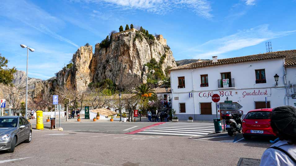
To get to Guadalest reservoir one of the options is to park in the village of Guadalest and walk down to the reservoir.
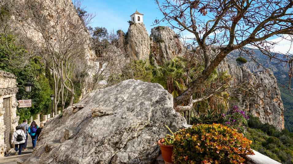
Guadalest was declared a Historic-Artistic Site in 1974 and one of ‘The Most Beautiful Villages in Spain’.
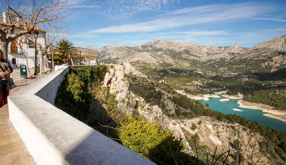
Guadalest Castle, at the top of a rock (at 595 m), offers impressive panoramic views of the valley and Guadalest Reservoir.
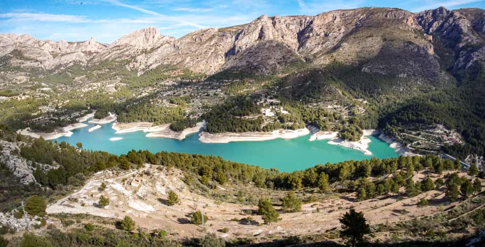
The slopes of the valley have several small white villages, of which Guadalest is the best known. The blue reservoir is perfect for swimming, canoeing or paddle surfing.
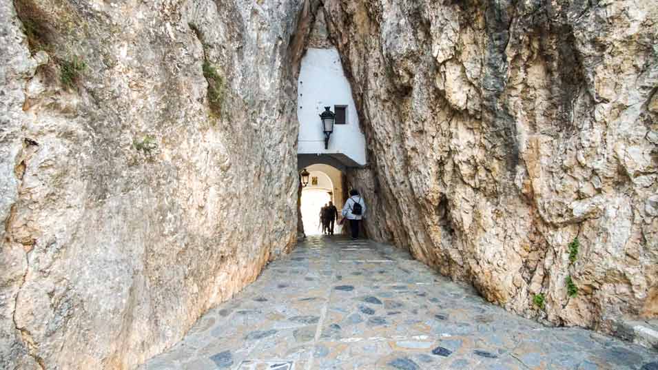
The town of Guadalest has many museums and streets with original nooks and crannies.
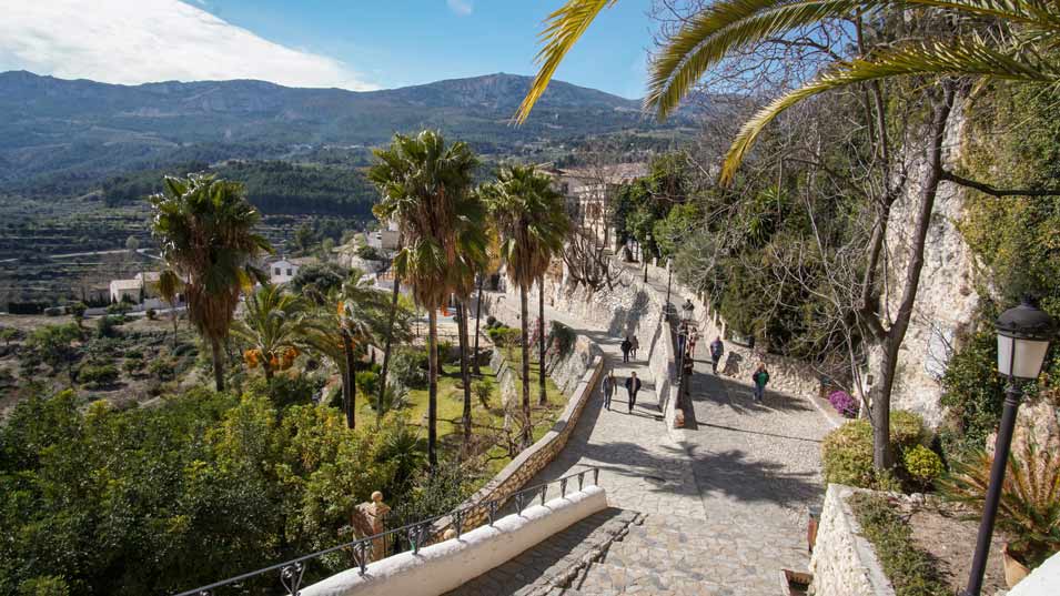
The path to go up to the Castle has beautiful views.
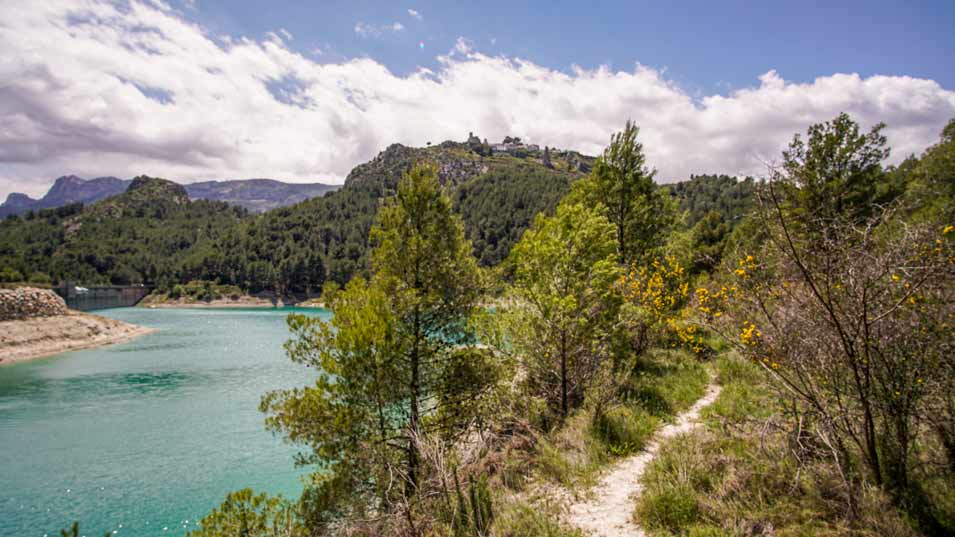
To the left of the photo, is the dam. You can cross it and drive on the cement road that goes around the lake or walk on the dirt roads next to the water. At the top of the mountain, you can see the town of Guadalest.
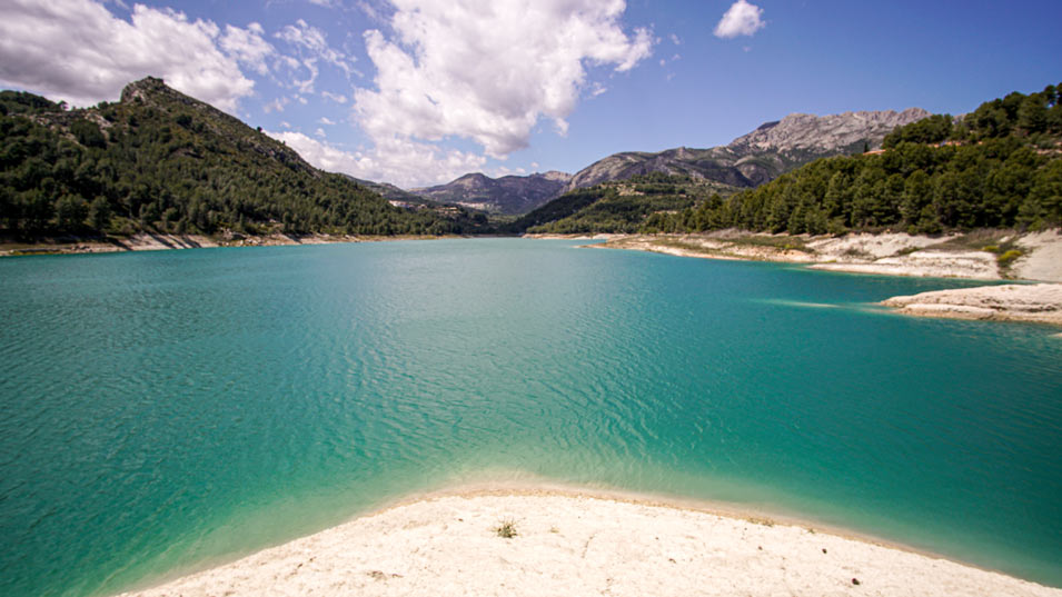
The blue water of the reservoir is impressive. Turtles live here.
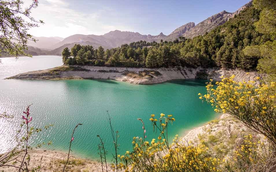
Guadalest valley is surrounded by the Aitana, Serrella and Xortà mountains. Aitana is the highest in the entire Valencian Community (1,558 meters).
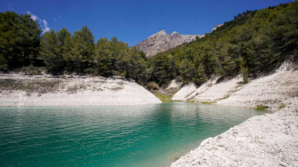
The reservoir has a circular route for hikers with beautiful views (see the Things to Do section below).
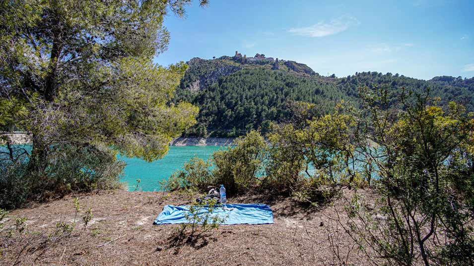
Guadalest Reservoir is ideal for taking a dip. The town of Guadalest is at the top of the mountain.
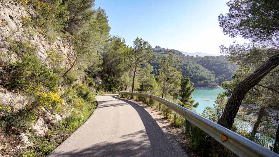
The paved road that surrounds the reservoir is not busy. It’s ideal for a walk or by car.
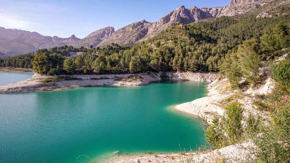
To go swimming, Guadalest beach (in the Beniardá area) is the best. Many areas of the reservoir have steep shores, making access to the water more difficult. Every year in June there is a swim across Guadalest Reservoir.
%
DIFFICULTY LEVEL
SWIMMING HOLES
IN ALICANTE

Check out the best Swimming Holes & Places to Swim INLAND!
Algar Waterfalls
Toll Blau
Barranco de la Encantada
Salt de Jijona
Guadalest Reservoir
Swimming Safety
Read these Tips
&
be Safe
when Wild Swimming
DESTINATIONS
UK
Spain
Bali
Belize
Mexico
Trinidad and Tobago
Costa Rica
India
Martinique
Keep it Clean!
The Rules

![]() Like us on Facebook!
Like us on Facebook!
![]() Facebook Posts
Facebook Posts
HOW TO GET TO - Guadalest Reservoir
Getting There
Getting There
How do I get to the Guadalest Reservoir?
It is easy as it’s well signposted and the roads are paved and in good condition. You have several accesses, in Guadalest and Beniardá. Both are an hour’s drive from Alicante. The fastest way to get there is to take the A-7 highway and the CV-70 regional highway.
There is a parking lot next to the reservoir at the feet of Guadalest. Yet, since the ‘Beach of Guadalest‘ is close to Beniardá, we recommend parking there and walking down. In Beniardá you can leave your car at the entrance of the town (next to the restaurant La Mezquita). Or a little further down at the public car park. Go down to where the Town Hall is, continue down the street and go under an arch. Leaving the village you can enjoy great views of the reservoir. Keep walking down the road and pass the municipal swimming pool until you reach the bridge crossing the Guadalest river. Before crossing the river, on the left, you will hear a waterfall. Cross the Guadalest River bridge and follow the road that continues to the right. There is a sign of ‘Presa de Guadalest’ (dam of Guadalest). Follow the curvy road until you reach a junction with a new sign. At the crossroads, go right, following the road around the dam. You will have magnificent views of the mountain of Aitana and the villages (Guadalest, Benimantell, Benifato and Berniardiá) as you arrive at Guadalest swimming lake.
Transport Options
There is no public transportation to Guadalest Reservoir but there is to the nearby villages. From there you can go by car or on foot. The easiest way is to drive to Guadalest or Beniardá and walk from there.
Around the reservoir, there is a narrow, winding road that is very quiet. It has beautiful views of the reservoir, the mountains and the valley. It’s not recommended to go with a large motorhome, but if it is a small one it should be fine.
Parking
There is a small parking lot right on the edge of the reservoir, where the dam is. It does not have many spaces so it fills up early on summer weekends. You can cross the dam on foot or by car. Follow the road towards Callosa d’en Sarria to get to the dam. Turn following the ‘Presa de Guadalest’ (Guadalest Dam) signpost.
You can also park in several car parks in the village of Guadalest that cost €2 a day. From there you will have to walk down the road that leads to the Sports Center until you reach the dam.
You can also park in Beniardá, which is closer to the Beach of Guadalest. You will have to walk through the town, follow the road that goes down to the reservoir and cross the river.
Location
Coordinates
Villages Nearby
Beniardá (300 m), Guadalest (300 m), Benimantell (700 m), Benifato (1600 m)
Level of Difficulty
Time to Walk to Swimming Spot
Drinking Water Spots
%
DIFFICULTY LEVEL
USEFUL INFORMATION - Guadalest Reservoir
Handy Things to Know
Entrance Fee
When to Go & Opening Times
Guadalest valley is surrounded by mountains and this influences its characteristic climate. It has summers with milder temperatures and more moderate winters. It is a place that you want to visit at any time of the year. It’s always open. During the summer and even weekends, it is not a place that gets crowded like many other lakes for swimming.
The climate and the dryness of the land of Guadalest favour the development of the almond tree. The flowering of the almond trees is from mid-February to the end of March approximately. It’s a beautiful natural spectacle.
Activities
Swimming in the lake, paddle boarding, kayaking, hiking and picnic. A solar boat gives a tour of the reservoir (summertime by appointment). When the water is high, people take their boats, especially in summer.
Facilities
Kids
Dogs
Although dogs are officially not allowed to take a dip, they go swimming on the part of the reservoir close to Beniardá.
Skinny Dipping
No
Wheelchair Access
No
Restrictions
Managed by
Things to Do – Guadalest Reservoir
Things to Do
Things to do near Guadalest Reservoir
There is a 9.63 km circular hiking trail that goes around the lake. At one side of the lake, the path runs parallel to the reservoir. It is 2 km and takes about 30 minutes. Yet, on the other side of the lake, the route is very winding. In total, the route is about 3 and a half hours.
You can also cross the dam by car and follow the road that takes you around the lake. In half an hour you will be back in the village of Guadalest. It is a very narrow road, recently paved and with many curves. It’s not busy, so you can enjoy the landscape.
We recommend a visit to one of the villages in the valley. Guadalest (200 inhabitants) is the most touristy and well-known, but all are worth it. The views of the valley and reservoir from Guadalest are impressive. The castle (Castell de Guadalest) is at the top of the cliff, at 595 m of altitude. It’s surrounded by Xortà and Serrella mountains to the north and Aitana mountain to the south. It was declared a Historic-Artistic Site in 1974. Besides, it’s one of ‘The Most Beautiful Villages in Spain’. Guadalest also has many quirky museums (salt and pepper shakers, microminiatures, dollhouses, vintage cars, bicycles and historical vehicles, ethnological and torture tools).
Check out these amazing natural pools & places to swim in the province of ALICANTE!
Algar Waterfalls are close to Benidorm and possibly are the most beautiful waterfalls in Alicante. The crystalline natural pools in the course of the river invite bathing or having a picnic next to them.
For a dip in beautiful swimming holes in Alicante, check out Barranco de la Encantada (swimming hole with waterfall) and Pou Clar (group of small swimming holes).
To swim on the coast in Alicante, Cala Granadella, Cala Portixol, Cala Ambolo and Cala Moraig are all amazing. They will remind you of Ibiza! To the south of the city of Alicante is Playa del Carabassí, a beach with golden sand protected by big dunes and pine trees.
Where to Eat
There are no restaurants or bars on the reservoir itself. You can go to restaurants in the villages of Guadalest (you can even eat in the castle of Guadalest), Benifato, Benimantell and Beniardá. The star dish is the ‘olleta de blat’ (pot of wheat).
The microclimate of this area favours the growth of ‘nísperos‘ (medlars). This fruit has a ‘Protected Designation of Origin’ in 19 Alicante municipalities. You could take local products, such as olive oil, honey, almonds as souvenirs. This will help the local economy and fight the depopulation of these inland valleys.
Accommodation
Geography
Altitude
Size
Under Foot
Maximum Water Depth
The depth of the reservoir is 94 m in some parts. If you get into the water in the beach area near Beniardá, the depth gradually increases.
Minimum Swimming Level
Most of the shore of Guadalest reservoir has a sudden drop in depth as you enter the water. Half a meter from the edge, it can be very deep already. That is why you must know how to swim. One of the few places in the reservoir where you can enter the water walking is on the ‘beach of Guadalest’ near Beniardá.
Shade
How Clean is the Swimming Spot?
Water
Underwater
Water Temperature
Water Colour
How Clean is the Water?
SWIMMING HOLES
IN ALICANTE

Check out the best Swimming Holes & Places to Swim INLAND!
Algar Waterfalls
Toll Blau
Barranco de la Encantada
Salt de Jijona
Guadalest Reservoir
Keep it Clean!
The Rules

Swimming Safety
Read these Tips
&
be Safe
when Wild Swimming
DESTINATIONS
UK
Spain
Bali
Belize
Mexico
Trinidad and Tobago
Costa Rica
India
Martinique
![]() Like us on Facebook!
Like us on Facebook!

